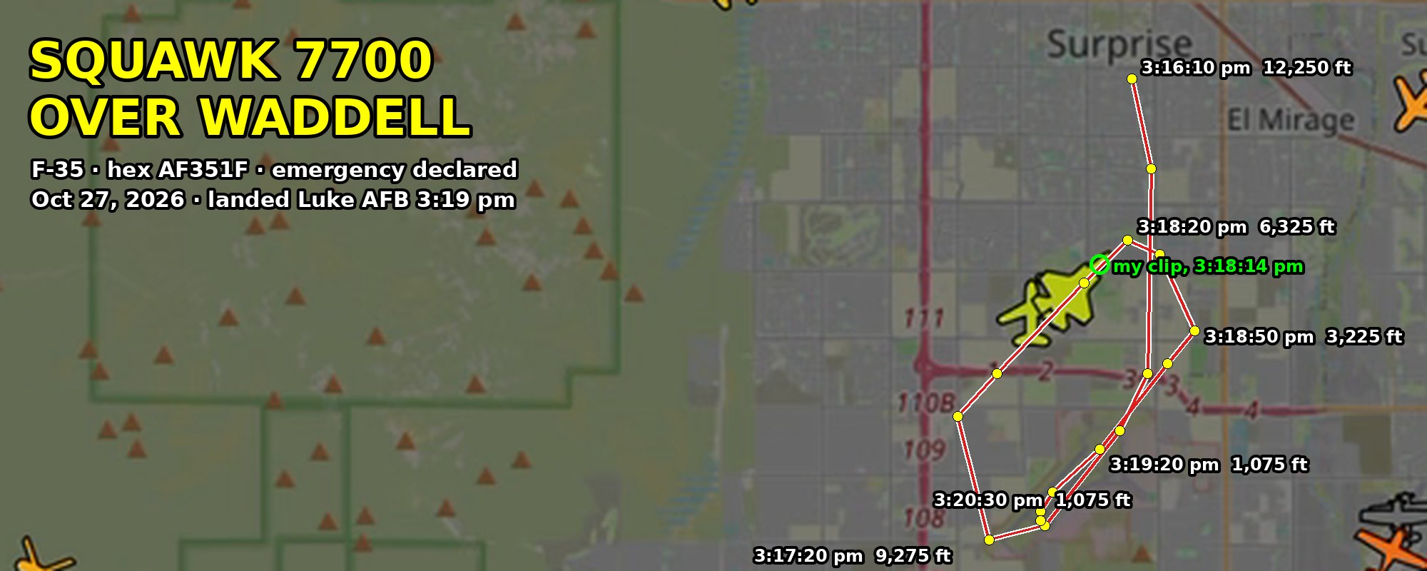
Seven parts, five videos, 2,100 words. At 3:15 pm on October 27, 2026, two F-35s came over Waddell, one circling the other, and the steady one trailed a dense white plume from underneath while the people below smelled fuel. The public flight record shows that jet squawking 7700, the international emergency code, at 6,000 to 7,000 feet over Waddell and Surprise, then dropping at more than 7,000 feet per minute onto Luke Air Force Base's runway 21 sixty-six seconds after the clip was recorded. By Blake S. Davis, Waddell, Arizona. Filed the night it happened; Luke Air Force Base has been asked for comment and the story will be updated. Updated October 28, 2026 with the 7700 code at every step of the replay and six screenshots from its first frame to its last.
What I saw
At about 3:15 on Tuesday afternoon, October 27, two F-35s came over my house in Waddell, and one of them was wrong. My son and I were in the backyard. We live under Luke Air Force Base's pattern and watch these jets every day. I know what they look like when they are working.
One jet flew straight and steady. The other flew around it in a tight little track — above it, below it, off its side — the way a pilot flies when he is looking another jet over. Then the steady one started trailing a dense white plume from underneath. I saw it start toward the front of the jet, not just off the tail. The sky was cloudless and the afternoon was warm. This was not a contrail.
Then the smell reached the ground. Not the burnt-exhaust smell we get every day under the pattern — a raw, oily, fuel smell. Nothing wet landed that I could see. We went inside.
At 3:18:14 pm I got my phone up and recorded four seconds of the steady jet. By then it was southeast of us, heading northeast, the plume stretched straight back behind it. My phone wrote that timestamp into the file. That clip and the public flight-tracking record are what this story is built on.
What the tracker shows
The pilot declared an emergency. ADS-B Exchange's replay for Tuesday afternoon shows an F-35 — hex code AF351F, broadcasting the factory-default flight ID F35LTNG, flagged military, type F35 — squawking 7700, the international emergency code, from before 3:16 pm until it stopped on Luke's runway. The jet was not broadcasting ADS-B position; the site placed it by multilateration of its transponder replies, and the FAA's own radar rebroadcast of the same target tracks it to within a hundred meters.
The readings below are copied from the aircraft panel in that replay. Times are MST, altitudes are what the transponder reported, and Luke's field elevation is 1,085 ft.
| Time | Altitude | Descent rate | Position | What it was doing |
|---|---|---|---|---|
| 3:16:00 | 13,000 ft | −5,120 ft/min | 33.633, −112.374 (Surprise) | First frame of my replay recording: coming straight down from the north at 352 kt, already squawking 7700 |
| 3:16:10 | 12,250 ft | −5,160 ft/min | 33.619, −112.369 (Surprise) | Still straight down, 411 kt |
| 3:16:50 | 10,575 ft | −368 ft/min | 33.545, −112.372 | Over the north edge of Luke, briefly level |
| 3:17:10 | 10,025 ft | −1,808 ft/min | 33.525, −112.391 | Over the base at 10,000 feet |
| 3:17:20 | 9,275 ft | −2,624 ft/min | 33.522, −112.405 | South of the base, left turn to the west |
| 3:17:40 | 7,375 ft | −5,256 ft/min | 33.548, −112.413 (over the 303) | Turning north |
| 3:18:10 | 7,075 ft | −664 ft/min | 33.576, −112.381 | Steady leg northeast, north of the base |
| 3:18:14 | ~6,800 ft | 33.580, −112.377 | My clip. Two miles south-southeast of my house, heading northeast | |
| 3:18:20 | 6,325 ft | −2,352 ft/min | 33.585, −112.370 | Northernmost point; right turn begins |
| 3:18:40 | 4,125 ft | −7,216 ft/min | 33.576, −112.354 | Turning south for the runway: the steepest descent rate in the replay |
| 3:18:50 | 3,225 ft | −6,936 ft/min | 33.566, −112.353 | Northeast of the base, nose on the runway |
| 3:19:00 | 2,400 ft | −5,840 ft/min | 33.559, −112.360 | |
| 3:19:10 | 1,525 ft | −5,008 ft/min | 33.551, −112.369 | About 450 ft above the runway, still coming down at 5,000 ft/min |
| 3:19:20 | 1,075 ft | 33.541, −112.377 | On runway 21. Touchdown between 3:19:10 and 3:19:20 | |
| 3:20:20 to 3:21:40+ | 1,075 ft | 33.526, −112.392 | Stopped at the southwest end of the runway, not moving, through the end of the replay I recorded |
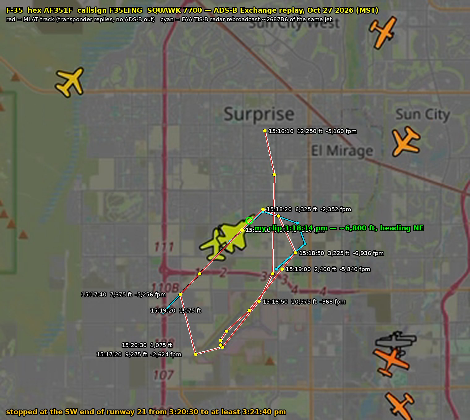
The track, plotted from the panel readings. Red is the multilateration track with altitudes and descent rates; cyan is the FAA radar rebroadcast of the same jet. The green circle is where it was at 3:18:14 pm when the clip was recorded.
Sixty-six seconds separate my clip from the pavement. Twenty seconds before touchdown the jet was coming down at nearly 7,000 feet per minute from 2,000 feet above the ground. That is a flameout-pattern arrival, the way a single-engine fighter is flown home when the pilot is not sure the engine will keep running: stay high, confirm the runway, spiral in steep. A normal recovery arrives at 1,500 to 2,000 feet and breaks into the pattern. This jet did not. It landed and sat at the end of the runway for more than a minute, which is what an emergency landing looks like from above when the trucks are waiting.
Added October 28, 2026: the 7700 code itself, first frame to last.
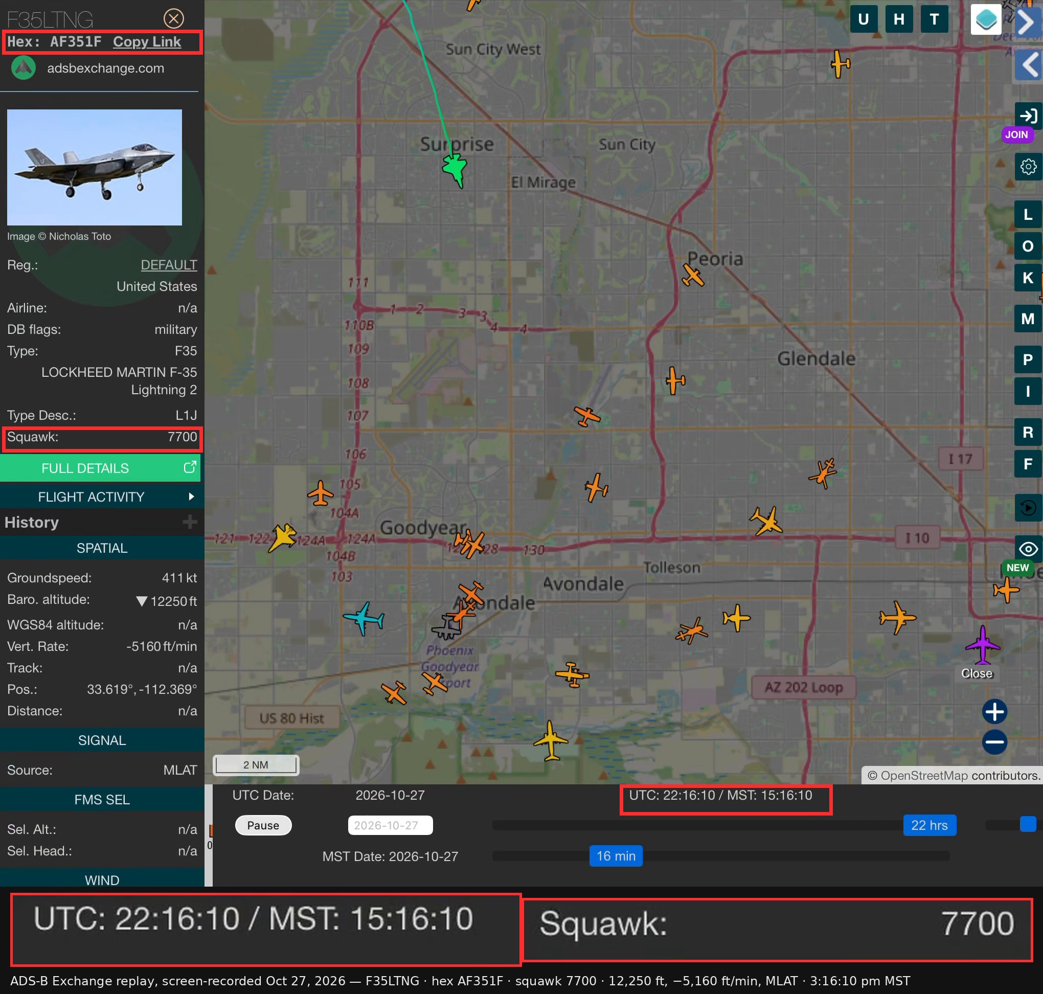
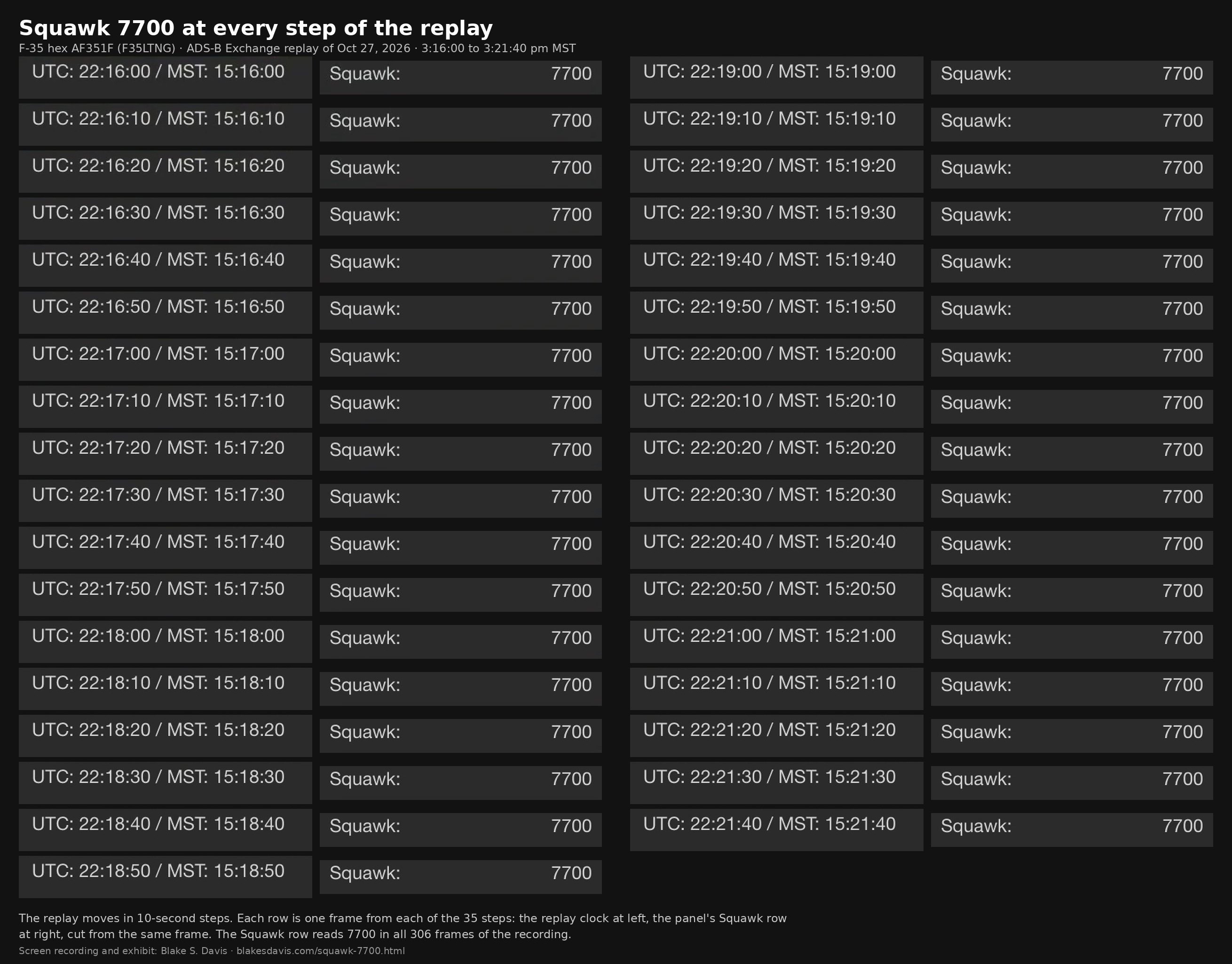
Six screenshots from the same recording, first frame to last. The red ring is AF351F on the map; the boxes are its hex, its squawk and the replay clock; the line under each frame prints that frame's readings. The trail fills in as it goes: straight down over Surprise, over the base at 10,000 feet, the loop west and the leg northeast, the steep turn south, and runway 21. Tap any frame for the full-size screenshot.
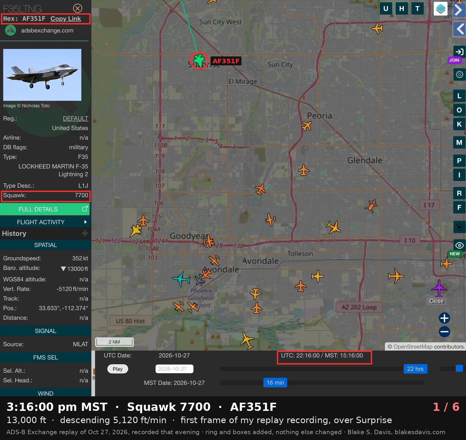
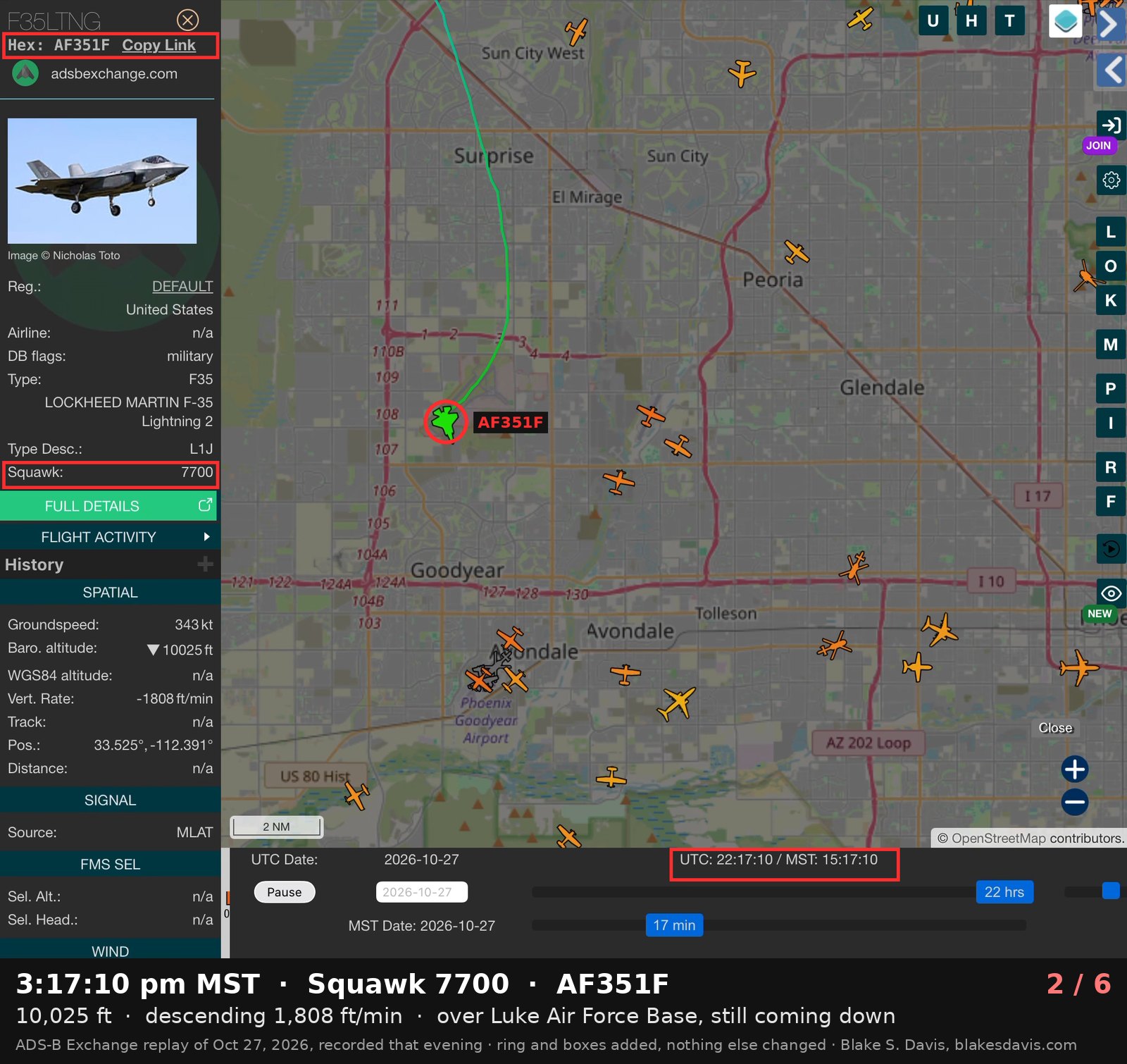
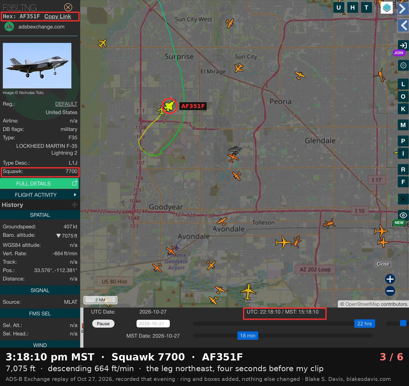
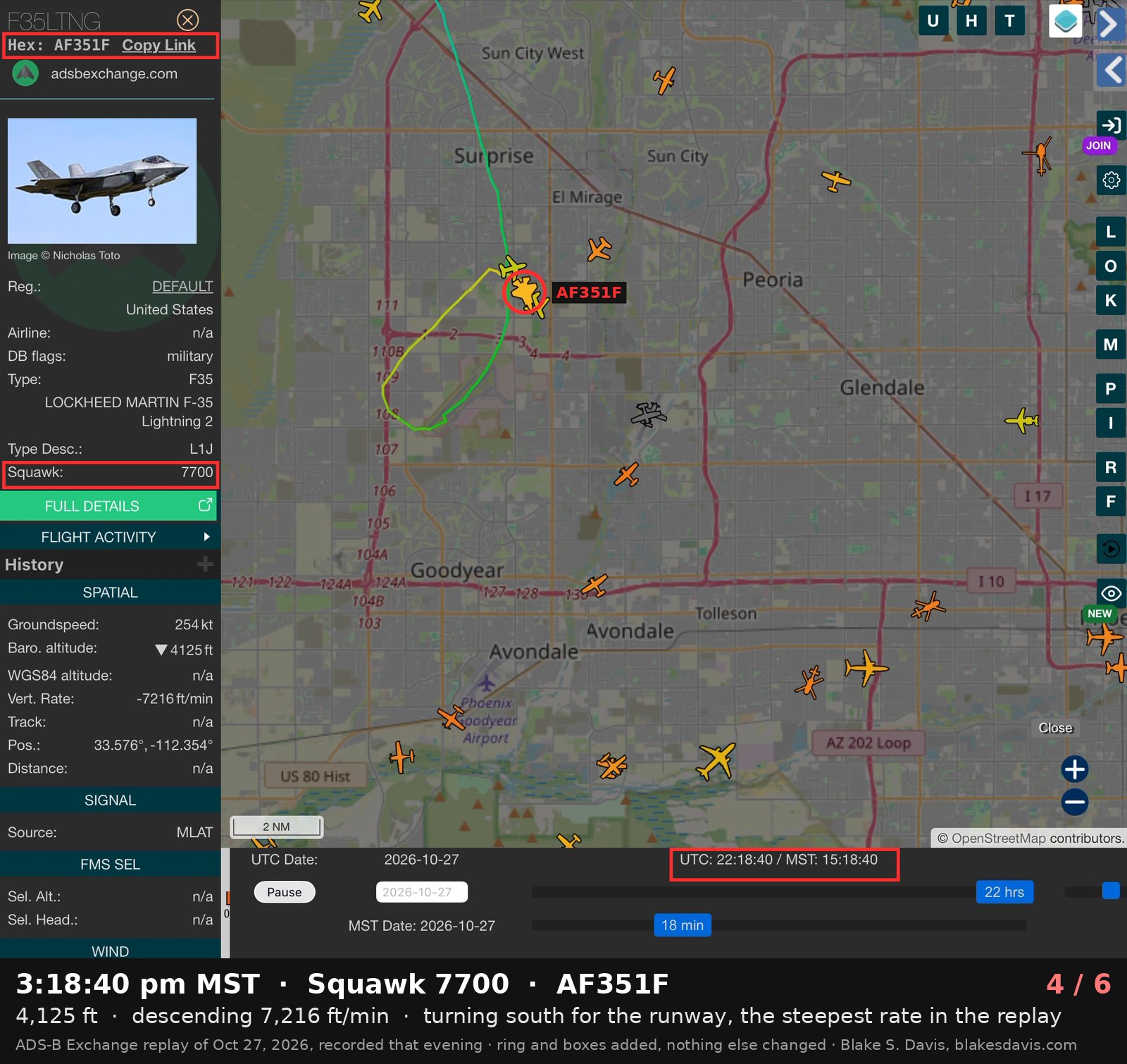
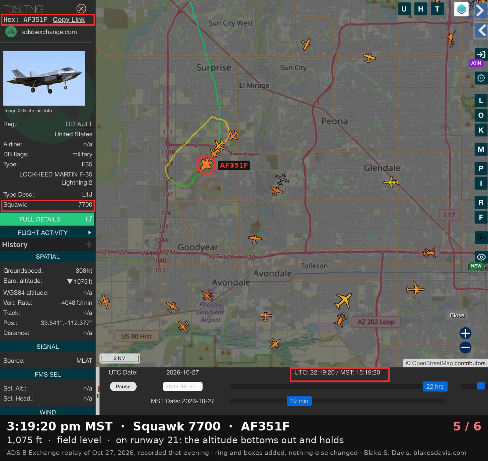
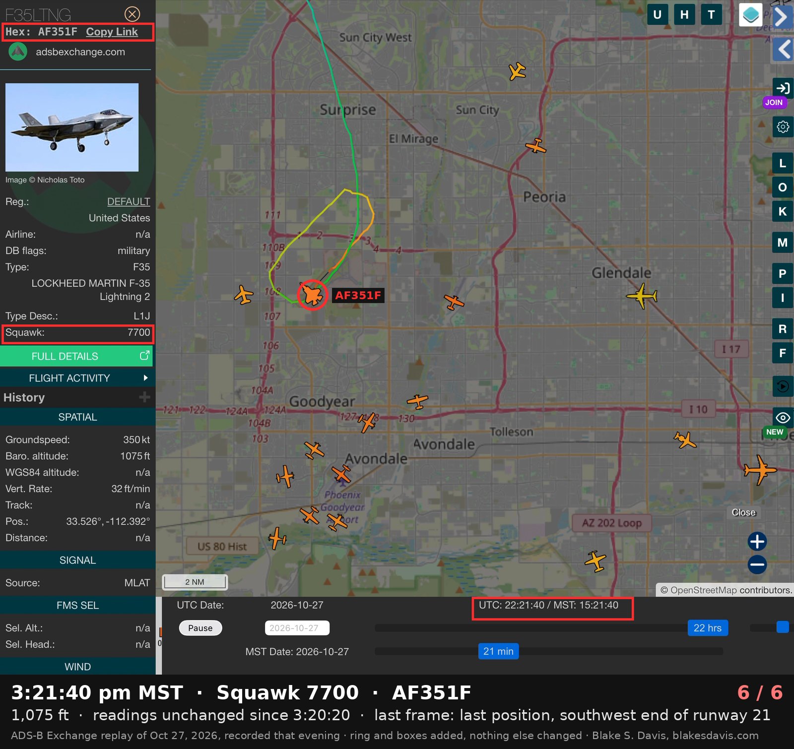
Browser chrome cropped off; the ring, the boxes and the caption line added; nothing else changed. All six on one sheet: f35-squawk-7700-replay-sheet.jpg.
What the video shows
The plume was something coming off the jet, not water condensing behind it. Three things in the clip rule out a contrail. The jet is big in the 4K frame — even at my phone's maximum zoom its wingspan works out to about two miles of slant range, which matches the tracker's position — and at 6,800 feet over the West Valley on a cloudless October afternoon the air is above freezing; exhaust contrails need air tens of degrees below zero. The plume also begins right at the airframe with no gap, and contrails always have one.
Enlarged frame by frame, it is a single dense white stream, as wide as the engine nozzle where it starts, riding dead on the jet's centerline. Across nineteen frames its axis sits within one pixel of the aircraft's centerline — a foot or so at that scale. It begins around the back third of the fuselage, ahead of the stabilators and ahead of the nozzle exit, and runs straight back with the lumpy texture of fluid caught in the exhaust.
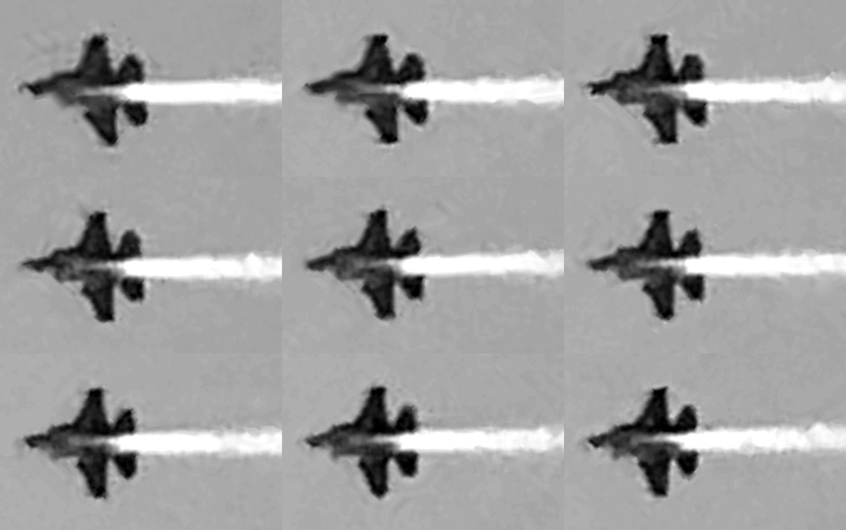
Nine frames from the first 1.3 seconds, rotated so the jet flies left to right and enlarged about four times. The plume starts at the back of the fuselage between the two stabilators and runs straight down the centerline.
That is not where an F-35 dumps fuel by design. The F-35 jettisons through a valve flush with the underside of the wing — Lockheed Martin's program chief Tom Burbage described it that way in 2012, when a Pentagon review flagged that the design wets the airframe with fuel and poses a fire risk — and the test jets carried fuel-indicating paint on the left flaperon and stabilizer because the port sits under the left wing. A dump should show as a stream off the left wing, ten to twenty pixels off center in these frames. There is no trace of one.
So the fluid was coming off the aft underside of the fuselage into the exhaust. Two things do that: fuel from a leak somewhere forward in the airframe, carried aft by the airflow, or dumped fuel washing back along the belly — the exact hazard the Pentagon flagged in 2011 and Lockheed said it fixed before any Luke jet was built. The clip cannot separate those two. I saw the plume start toward the front with my own eyes, which the camera cannot resolve at that distance, and what I watched was the second: the wash-back the Pentagon flagged — an emergency dump, and then the landing. Either reading is fuel coming off a fighter over homes, and the squawk makes the distinction academic: the pilot called it an emergency himself.
The second jet
The jet circling the emergency aircraft was its wingman doing a look-over, and it is nowhere in the public record. When a flight member has a problem, the wingman closes in and flies around and under him checking for leaks, damage and the position of the gear, while the emergency jet holds smooth and steady to give him a stable look. One jet steady, one jet crawling around it in a small orbit near the field is the picture of an in-flight emergency, and it is what I watched over my house before I started recording.
The wingman never shows up on ADS-B Exchange: no ADS-B, no multilateration fix, no radar rebroadcast. Fighters fly with ADS-B out switched off most of the time, and a jet doing a look-over has no reason to be broadcasting. The one other contact in the replay, a dynamic hex “~2687B6” with no callsign, is the FAA's own radar return for the emergency jet, uplinked over TIS-B. ADS-B Exchange says so on the panel — an “ATC contact broadcast” that “often corresponds to an MLAT contact for the same aircraft” — and the positions prove it: at 3:17:50 both read 33.557°, −112.403°, identical to the hundred meters, and they stay together through the turn and the descent. Two jets in that look-over means the FAA would have rebroadcast two radar targets. It rebroadcast one.
My replay recording opens at 3:16:00 with the jet already coming straight down from the north at 13,000 feet, already squawking 7700. Before that, its transponder returns come and go in the public data, so the record does not show the jet's full pattern over Waddell during the minutes I watched it circle with its wingman. Where it flew from the moment the pilot declared the emergency, and where the second jet flew, is something only the base can answer. It is on the list below.
Why it matters
Fuel came off a fighter at 6,000 to 7,000 feet over neighborhoods, and the people under it found out by smelling it. Boeing's own guidance, cited in industry safety briefs, is that fuel jettisoned above 5,000 to 6,000 feet above the ground vaporizes completely before it reaches the surface. This jet was at 5,000 to 6,000 feet above the ground on the leg I filmed, right at that floor, and lower on the turn before it. Nothing wet landed in my yard. The smell did, and that is what a mist of kerosene does when it arrives at ground level too thin to see.
The FAA's controller handbook treats fuel dumping as an event other people need to know about. Section 9-4-5 of Order JO 7110.65 requires the controller in contact with a dumping aircraft to inform the other facilities concerned and to broadcast an advisory every three minutes until it stops. That is for pilots on the frequency. There is no equivalent for the family in the backyard, and there was no notice to anyone on the ground Tuesday that I have found.
Luke has a record of these events reaching the public through trackers first and the base second. On April 20, 2026, an F-35A from Luke squawked 7700 over the Phoenix area, was picked up on Flightradar24 by its serial number, 13-5067, and landed on runway 21L with emergency vehicles waiting. The base confirmed afterward that the pilot had an “unsafe gun” indication and said the emergency posed no threat to the community. That confirmation came because the trackers forced the question. Tuesday's jet was tracked the same way, by anyone who looked. What came off it and over whose houses is a question only the base can answer, and it is the one I have put to them below.
Questions sent to Luke Air Force Base
I sent the following by email to the 56th Fighter Wing Public Affairs office, the base's designated channel for media requests, on the evening of October 27, with a request for a response by Wednesday morning, October 28. This story will be updated with whatever comes back.
- Did an F-35 assigned to Luke declare an in-flight emergency between 3:00 and 3:20 pm MST on October 27, 2026, and land on runway 21 at approximately 3:19 pm?
- What was the nature of the emergency?
- Did the aircraft jettison fuel, or was it leaking fuel or another fluid, during the recovery? If fuel was jettisoned, at what altitude, over what area, and how much?
- The aircraft's transponder returns are intermittent in public tracking data before 3:16 pm. What was the aircraft's route and altitude from the time the emergency was declared until it landed, and did it overfly Waddell?
- The aircraft was tracked at 6,000 to 7,000 feet over the Waddell and Surprise area with a visible plume, and residents on the ground smelled fuel. Was any notification made to the public, the cities of Surprise or Glendale, or Maricopa County?
- Was a second F-35 accompanying the aircraft and performing a visual inspection, and what was its route?
- Which squadron was the aircraft assigned to, and was the pilot a student or an instructor?
- Did the aircraft stop on the runway after landing, and were emergency response vehicles dispatched?
- Has the aircraft been inspected, and what was found?
Check it yourself
Everything above is reproducible from public data and one phone clip.
- The track: open globe.adsbexchange.com and add
?replay=2026-10-27-22:12&icao=af351fto the address. That is 3:12 pm MST (Arizona is UTC−7). Tap the F-35 and the panel shows the hex, the F35LTNG flight ID, the 7700 squawk, altitude and descent rate as the replay runs. The jet appears under its real hex via multilateration and again as the FAA radar rebroadcast “~2687B6.” - The clip: recorded on an iPhone 12 Pro Max at 3:18:14 pm MST; the file carries the timestamp
2026-10-27T15:18:14-0700. It runs 4.4 seconds; the jet is in frame for the first 1.3. The original file is the first video above, re-encoded for the web and otherwise untouched. - The plume measurements: every frame with the jet in it was rotated so the airframe's axis was horizontal, the trail's bright ridge was fitted section by section, and its offset from the nose tip and from the midpoint between the stabilators was measured. Mean offset across nineteen frames: under one pixel, scatter about three. The wingspan measured about 88 pixels, which at the phone's maximum 7× video zoom puts the jet within roughly two miles.
- The replays: the three ADS-B Exchange videos above are screen recordings of the replay made the same evening, with the browser chrome cropped off and nothing else changed.
- The F-35 dump valve: Lockheed Martin's Tom Burbage, quoted by Airforce Technology in 2012, on a fuel dump “valve that is flush with the wing” and the Pentagon's finding that the design wets external surfaces. The left-wing location is described in F-35 test-program discussion on F-16.net of the fuel-indicating paint on the left flaperon and stabilizer.
- The April 20, 2026 emergency: reported by AIRLIVE from Flightradar24 tracking of serial 13-5067 squawking 7700 and landing on Luke's runway 21L; the Air Force's later statement on the “unsafe gun” indication was carried by Arizona outlets.
- The evaporation floor: Boeing Aero magazine guidance that fuel jettisoned above 5,000 to 6,000 feet vaporizes before reaching the ground, as cited in the PRISM research brief on fuel jettison. FAA Order JO 7110.65, Section 9-4, on controller duties during fuel dumping.
Blake S. Davis lives in Waddell, Arizona, under the Luke Air Force Base traffic pattern. Published October 27, 2026. Updated October 28, 2026: added the 7700 exhibits and six replay screenshots under the tracker video, and four readings to the table: the replay's first frame (3:16:00, 13,000 ft), 3:17:10 over the base, its steepest descent rate (7,216 ft/min at 3:18:40) and 3:19:10, about 450 ft above the runway. Corrected October 28, 2026: the paragraph on where the plume began now carries my own read, as I gave it that afternoon — a dump washing back, then the landing — in place of a conclusion I never drew. Updates will be dated.